Muckleford and the First Generation Aussie Magees
Muckleford and the First Generation Aussie Magees
John Magee emigrated from Kildallan, County Cavan, Ireland. His father was Robert Magee and mother Mary Ann Magee née White. His birth date and the exact year he arrived in Australia are a matter of debate.
- His 1899 death certificate when he died at age 69 suggests a year of birth of 1830.
- However, the death certificate indicates he was 33 at marriage in 1869, making year of birth 1836, but perhaps most convincingly the marriage certificate indicates he was 34, making year of birth 1835.
- The death certificate showed he had been in Victoria for 48 years, making an arrival of 1851. That makes him 21 when he arrived (69 – 48).
- On the other hand, Patricia Magee reports that he arrived in Melbourne on the James Baines in 1855. In fact there were nine John Magees who arrived in the 1852 to 1863 period according to Public Record Office Victoria.
- Even his place of origin is not clear cut. His daughter Elizabeth's and son John Alexander's birth certificates claim John came from County Carlow. The siblings had the same birth records registrar who perhaps was hard of hearing. His death certificate says he was born in Cavan while his marriage certificate is closest, indicating he was born in 'Kilderran', County Cavan. Noted Irish genealogist John Grenham explained that Kilderran would have actually been Kildallan.
Let's say for the sake of it that he arrived in 1855. When he landed the latest place name on everyone's lips was Muckleford. It was the gold flavour of the year. Rumours of gold discoveries in Australia had flown around the world, attracting thousands upon thousands of hopeful diggers. The rumours were as strong in Ireland as anywhere else, particularly because the disastrous effects of the potato famine of the second half of the 1840s were still being felt. Poverty was endemic and the chance of quick riches and a new start was more than tempting.
No evidence has surfaced so far about John Magee's whereabouts between whenever he arrived and 1865 but it's not hard to conjecture that he was tempted to the goldfields at or near Muckleford. This wonderful report in The Mount Alexander Mail of 25 May 1855 explains why.
Muckleford Rush
New diggings are now becoming so common that the idea is gradually forcing itself on peoples' minds, that Australia is one vast goldfield. Gold has been found almost wherever a proper search has been made, and it almost seems absurd that any one should take the trouble to rush to any distant locality, instead of digging beneath his feet. Yet the disposition to rush is so strong in the mind of the Victorian digger, that it is a perfectly safe speculation for any publican to build a large hotel in any desolate spot; for he can easily bring a few thousand customers to his bar by spreading a report that the ground in his vicinity is auriferous, and by employing a few parties to act as decoys in sinking holes around his house. If these parties are mysteriously quiet in their operations, and are not discovered too soon by the public, the dodge is sure to succeed, and it is fortunate the soil of our adopted country is sufficiently rich to admit of few mistakes on the part of intending publicans as to the choice of a locality. Many new rushes have been preceded by a public house, and were it not for these 'publicans' rushes', as they are termed, the country would need prospecting parties even more than it does at present.
We do not say the Muckleford diggings have been initiated in this manner, although it may be remarked as a coincidence, that Monk's new hotel, in the immediate neighborhood of the new diggings, is just approaching completion. The road to the Muckleford gold field (as we suppose it must be termed) is the direct route to Simson's, and presents the ordinary features of an Australian bush track. On both sides there are the unvarying alternations of hill and gully, and the traveller is shut in amongst the dusky green foliage and silvery trunks of the closely-packed denizens of the forest. The magpies flit from tree to tree, and the rooks overhead seem determined to imitate the human voice by every modulation of caw. Here and there the location of a party of sawyers meets the eye, and the scene is diversified by an occasional carcass of some decomposing bullock, or the solitary grave of some wayfarer of an earlier period in our colonial history. Towards the racecourse the scenery somewhat resembles that of an English park; the trees are more thinly scattered, and a beautiful lawn spreads itself in graceful undulations around. On the left hand, and on the banks of the creek, Monk's hotel has been erected, and the diggings commence a few hundred yards farther on. It is impossible to miss the road, for the holes are sunk in the very centre of it for some distance. On dit [They say] that a Commissioner and a few troopers set out to prevent the ripping up of the road, but after mature reflection, returned to Castlemaine without effecting anything. The country at this spot resumes its thickly wooded, quartz-reefy, and reddish-brown appearance; in fact, to use the words of an 'old hand' on the spot, "If there isn't gold at Muckleford, there ought to be." The main gully appears at present the favorite place, and every inch of the road, with the ground on both sides, is being taken down or marked out. At the head of this gully several parties have been doing well, and the general yield is said to be about three ounces to the load. Some have done more than this, however, and the opinion seems to prevail that the entire gully will prove remunerative. The lower end has not yet been bottomed, except in one or two instances, and therefore cannot yet be said to have been properly tried. Several diggers have come upon a tough cementiferous substance, which they have mistaken for the bottom, and have refrained from going deeper in consequence. The stuff lying on this bottom resembles the washing stuff of other localities, but is not considered to be the real stuff by those who have any pretensions to knowingness. The false bottom is occasionally intersected with the roots of trees, and it is, we believe, an axiom in mining tactics, that no true bottom can be perforated with roots. Should this theory be correct, many will have to go deeper than they imagined.
Besides the main gully, several adjoining gullies have been tried, and sinking has also been proceeded with on the hills. We were informed at several places that one party had taken out eleven ounces from one bucketful of stuff, and this report appears to be substantially correct. Other finds are spoken of, but it is difficult to distinguish rumor from fact. The gold is found in patches all over the surrounding district, and the diggings are very scattered. The principal drawback is the want of water, which necessary is sold at sixpence per pailful. About half-a-dozen stores have already been opened, and butchers' shops, with chaff-abounding butchers, are very prevalent. Provisions are sold at Castlemaine prices, and grog is apparently cheap and plentiful. At night everyone fires his pistols, and every dog barks his utmost, according to the established rule at all new diggings. There are no police, and at present, we are happy to say, no disturbances.
About 200 assembled to administer justice to a claim jumper on Monday, but we believe no infraction of the law took place. The population increases daily, and above 2000 persons are now on the ground. As a proof of the existence of gold at Muckleford, we may mention that a storekeeper at Castlemaine purchased this week twenty-eight ounces, the washing of ten loads of stuff, taken from a heap of about twenty loads of similar soil.i
Gold Gold Gold
In fact gold had been discovered in the area in 1851 and the first rush to Muckleford occurred in 1852:
By October 1852 the population reached its peak of 35,000, making it the most populous mining field in Australia. The miners quickly explored the network of gullies that extend from the major streams of Barkers, Campbells, Forest and Fryers Creek and the Loddon River.
The Castlemaine goldfield became famous as one of the greatest shallow alluvial gold diggings in the world. During the 1850s, the greatest period of gold production the world had ever seen, Victoria alone produced a third of the world's gold and Castlemaine became the third largest gold producer in Victoria after Bendigo and Ballarat. The amount of gold extracted during the early years can only be estimated, however during the five year period from 1859 to 1864, some 132 tonnes was escorted to Melbourne and Adelaide. This wealth gave Castlemaine, along with the other nearby centres, an international profile disproportionate to their size and fuelled their rapid development during the mid-19th century.
There were a number of large alluvial rushes to Muckleford during 1852. The former town of Muckleford was built next to Muckleford Creek on the Castlemaine–Maldon Road. There were 4,000 diggers by 1855 but it was on the wane by mid-1858. Large numbers of Chinese miners, however, continued to work small pockets using horse-puddling machines.ii
These observations about the early diggings around Castlemaine were revealing:
As one gold seeker observed it: Thousands upon thousands of tents extending through the gullies for about ten miles in every direction, lots of stores distinguished by flags, and slaughter houses which might be nosed a mile off, enough to breed a fever in the place – the ground full of immense holes, many of them 30 feet deep and the surface cut up by carts and mid-leg in dust … and the creek thronged with cradles and tin plans, and fellows washing … [for gold] … in every direction (Edward Snell).
It was a sight! Mounds of earth lying beside holes presented the dismal appearance of a graveyard, men washing dirt in tubs, carrying its colour on their skin, hair, hats, trousers and boots, miserable-looking low tents their places of refuge. Where water was to be seen it was puddle. The whole scene to a new chum was one of unspeakable squalor, surpassing all that his eye had seen or his fancy woven. (James Robertson, in Records of Castlemaine Pioneers, p. 47, Forest Creek, late 1852).
The washdirt often had to be transported to water sources — besides the enormous mass of persons stationary at the cradles, there is a moving population, from the various holes to the cradles on the water side, equally numerous. Some carry the earth on hand-barrows, made of two long wooden handles and a sack sewed long wise, on which they carry it. Some use wheel-barrows; others a piece of bark as a sledge, on which they place a bag full of earth, and draw it along the ground. Some carry it in sacks on their back, while the tin dish washers, of which there are hundreds, carry it in their tin dishes on their heads. (The Argus, 27 October 1851)iii
John Magee Surfaces
It took until 1865 for the first concrete piece of information to surface about John Magee: on 31 August 1865 he purchased at auction Lot 7 of Section 12, Parish of Guildford, East Riding of the Shire of Newstead. This allotment was actually located at South Muckleford. It's unsurprising that he chose to become a farmer as his father Robert was a farmer in Ireland. After a possible period of mining, farming would have been the natural choice.iv
Where Is Muckleford?
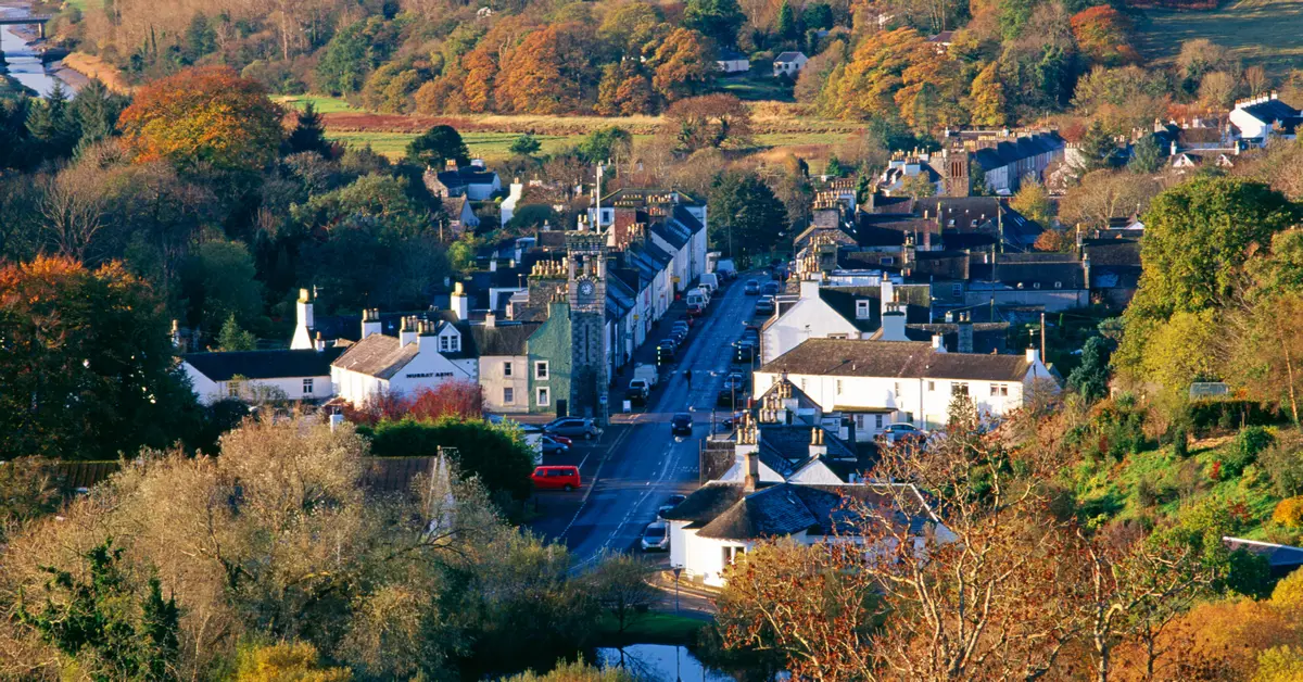
Muckleford is about 125 km north-west of Melbourne. It's a fairly large rural area with no discernible centre and no town. In this sense it is not unlike Kildallan. To its immediate east is Castlemaine, it extends almost to Maldon in the north-west, Welshman's Reef and Newstead are to the west and south-west, Strangways and Green Gully lie south, Guildford is south-east, and Yapeen and Campbell's Creek are to the east. It was roughly divided into North Muckleford, Muckleford and South Muckleford. North Muckleford for a time was known as Gowar, later spelled Gower, but which reverted to North Muckleford. The locale just west of Castlemaine was also known briefly as Wattle Flat.
It was named after the Muckleford pastoral run taken up in 1840 by G. W. Cole and F. W. Langdon. Its size by 1856 was 70,000 acres. The original run fairly closely approximated the named area which followed it.v
In turn, the Muckleford run was named after the English hamlet of the same name in Dorset.vi
If there ever was a focus of population it was at the part of Muckleford which formed at the crossroads of the Castlemaine–Maldon road and the Muckleford–Walmer road near the Muckleford Creek crossing.
A secondary focus was at South Muckleford where the Castlemaine–Newstead road crosses the Muckleford Creek. Some surveyed towns, such as South Muckleford, did not develop as expected and were known as 'paper townships'.vii
The Mining Life
Let's say John Magee, like many thousands of others, had been gold mining in the Muckleford or the wider Mount Alexander area from his arrival until 1865. It's worth talking more about mining development. Here's another excellent account to flesh out the scene.
The murders which occurred in the Newstead district in the late 1850s might be seen against a background of rapid social and economic change driven by the Victorian gold rush. It was a time when thousands of diggers descended on the bush near Newstead, in numbers which have never been repeated. This was an era when a great deal of lawlessness existed across the Colony, and the justice system was stretched in its ability to cope.
The discovery of gold in Victoria, in the early 1850s, precipitated a quite unanticipated wave of humanity pouring into the colony. As a result, Victoria's population went from 72,000 in 1850 to 534,000 by 1860.
Towns like Castlemaine and Maldon sprang up overnight, and by 1854 around 20,000 diggers were reported to be at work on the Maldon goldfield, which was to the north of Newstead.
So by 1857–59 Newstead was well established, having grown from a river crossing place to a small town with several hundred people living in the township area and servicing nearby farms. Along the banks of the Loddon River and adjacent areas, many small farms had been established, and in the forested country to the north east of Newstead township, gold mining was being prosecuted by miners who at times were numbered in their thousands.
Mining to the east of Newstead commenced around 1855. Auriferous ground was followed by miners west along the Castlemaine–Maryborough Road from South Muckleford, to Green Gully, and later into the Mia Mia Creek area. By May 1855, 2000 diggers were reported to be seeking gold at South Muckleford, and within a month or so diggers were hard at work in Green Gully. To slake the thirst of the diggers in the area 'Monck's Racecourse Hotel' had been erected at South Muckleford, and half a dozen shops had opened (all now long since gone). The bush was alive with people. The Mia Mia goldfield extended north to ground around Sandy Creek (the southern area of which was later known as Welshman's Reef). By April 1857, there were something like 1500 miners at work on the Mia Mia, and a street of stores, blacksmiths shops etc. had also sprung up in what only recently had been virgin bush.
So violent was the diggers' assault on nature that traces of alluvial mining throughout this area of bush are still clearly visible to this day, even though the mine shafts only extended a few metres into the ground in most instances. Fortunately, forest regrowth is gradually obliterating this evidence of this human industry.
Taken as a whole the mined area constituted several square kilometres of gold bearing land just east of Newstead township. The rush to these fields gradually subsided, but even in 1859 it was estimated that the population in the Newstead district was still around 2000, with many of these being connected with mining in the Green Gully/Mia Mia area. The area also attracted a significant number of Chinese miners.
Miners were very much a floating population, with an inclination to immediately respond to favorable news or even the rumor of a new goldfield, and 'rush' to a new diggings, often at very short notice, in the hope of 'striking it rich.'
There was also much hardship. Life for most miners and small farmers was very harsh. Water was often scarce, particularly in the summer when the Loddon River tended to become a chain of waterholes. Food could also be expensive. Much accommodation available was of the most basic kind, and people lived in tents or bark huts for years on end. Schools were also conducted in tents to begin with, for those children lucky enough to be able to attend class. Such medical treatment as was available was limited in scope, and any serious injury or illness could quickly result in death.
The gold rush period was dominated by single men seeking their fortune. In such an environment individual diggers needed to find a 'mate' to work with them, or work in small teams for safety and to be effective. Nevertheless, many family groups were also present on the gold fields. It was estimated that in 1856, the Castlemaine goldfields district European population of 25,700 was made up of 16,600 adult males (65%), adult females 3950 (15%) and children 5150 (20%).
In addition, there were about 4500 adult Chinese males present on the Castlemaine goldfields district at that time. Few Chinese miners brought wives and families to Australia.
Complicating the difficult living conditions, alcoholism was a serious problem. Hotels did a roaring trade, and such edifices competed with less salubrious inns or as they were politely called 'refreshment tents'. Less congenial establishments were the unofficial grog shanties, which seemingly existed for another purpose such as a store, much to the annoyance of the authorities. So widespread were these unofficial dens of alcohol abuse, that a correspondent from Newstead writing to the Castlemaine Advertiser in early 1859 was moved to exclaim, 'are there no police to look after the grog shops. They flourish here like mushrooms, and it is melancholy that nearly all the money got for wages here goes for drink, in these accursed places.'
Unfortunately, theft was endemic in colonial society. Robbery under arms was a hazard of the road, and individual travellers were particularly vulnerable. Theft of cattle and sheep was on a scale that farmers needed to be eternally vigilant or risk losing their livelihood. Newspapers would carry lists of horses 'missing' together with descriptions of the animal, and the amount of a reward offered for their safe return. In fact the return of 'lost' horses in exchange of a reward, became an industry in its own right. So bad did horse stealing become that no sale of a horse was legal unless the seller issued a proper receipt documenting the transaction. Unfortunately, horse thieves were often able to get around these restraints, with the aid of cleverly forged receipts.
Violent crime was prevalent, and it is said that many acts of violence, even murder, went unreported, a situation complicated by antipathy towards the police and related officialdom by much of the populace. This attitude subsided but slowly in the wake of changes brought about in the wake of the Ballarat Eureka rebellion in 1854.
Nevertheless, the police gradually became more effective. They were assisted by the emergence of newspapers throughout the more settled areas. News of serious crime could then be circulated widely and the assistance of the community sought to bring alleged criminals to justice.viii
Muckleford Expands and Contracts
A small gold rush occurred on 'Wattle Flat', not far from the Muckleford Creek during 1852. This was deemed to be part of the Tarrangower field which became Maldon, and apparently didn't last long before it was pretty much deserted. Toward the end of February 1854, there was another rush to the spot, and there were some 300-odd men working the field; but, again, within a month or so they had spread out into the nearby ranges. Later in the year, farming allotments were sold along the Muckleford Creek.
During 1855, another lead of gold was discovered slightly to the east of the previous rushes, and this time the boys settled down to some serious work – and more families chose to make their home on the flat.ix
The Orrville Hotel
It was during 1855 that a hotel appeared amongst all the other businesses which were catering to the diggers' needs. It seems that almost the entire length of the track from Castlemaine to Maldon was bordered by tent-businesses of every imaginable description.
Melbourne liquor merchants, Franks and Ivens, employed James Shorter to run their hotel, and it's interesting to note that in early 1856 the hotel boasted a room large enough to comfortably accommodate more than 30 guests for a public dinner put on by the 'Castlemaine, Muckleford, and Loddon District Agricultural Association', a body which had its beginnings in July 1854.
The Orrville Hotel was the centre of activity for the region. About 1852–3, there were plans afoot for a village of that name – but it never got off the ground, and only the hotel bore witness to the attempt. Situated on the main Castlemaine–Maldon road, the hotel also benefitted from the passing traffic, which included the mail coaches between the two townships.
There were still a number of miners in the immediate vicinity, along with the farmers, and there was no hardship involved in establishing a Post Office at the Hotel. James Shorter became Muckleford's first Postmaster.
Not long after the Post Office opened on 1st August 1857, the Muckleford diggings took off, again – with a vengeance. By February 1858 there were estimates of 2000 men on the 'new' diggings, and more on the way. Once more, the tent businesses set up camp (this time, several casinos were amongst the number), and the area flourished.
The Government of the day came to the party, spending money on clearing the road (sic), and even building a bridge across Muckleford Creek – which they later placed a toll on – but the diggers, once again, moved on fairly quickly.
Muckleford's main industry was farming. The early produce was grain crops, apart from one gentleman who cultivated tobacco for locally made cigars, but the rich alluvial soil supported a surprising array of enterprises.
During 1860, Muckleford was only one of the numerous localities which were affected by the State's 'flooding rains' after the drought. The little bridge which had been built over the creek of 'many fords', collapsed under the weight of one mail-coach, and forced the mails to reroute through the southern roads – much to the local residents' disgust. Earlier that year, Muckleford residents gratefully accepted land from one of the farmers, Patrick Scully, to be used as its own Cemetery.
By 1862, the toll-gate was in operation, a Church of England School had been established for the kids, and the long-awaited Farmers Common was finally in place for many of the smaller landholdings.
One amusing (from this distance in time) anecdote is worth sharing: The Mount Alexander Mail of 6 November 1863 reported that 'a very large brown snake was brought into this office yesterday, measuring six feet three inches. It sprang across the road opposite the Orrville Hotel, Muckleford, and actually lodged itself under the ample crinoline of a female who happened to be on the spot at the time. Fortunately she noticed the reptile, and sprang off with almost as much agility as the snake. The alarm was given, and the publican, Mr. Creber, assisted by others, soon despatched the unwelcome visitor'.
From the mid-1860s until 1879 there was very little mining activity in the immediate area, and the farmers continued to improve their holdings – they are in the majority in the 1869 Bailliere's Directory for Muckleford.
The Muckleford Post Office remained in the hotel, which had become delicensed, well into the 20th century. For the last years of its existence it was operated from the Murdoch family home until it finally closed in 1966.
Today, almost nothing remains of the Orrville Hotel; one single small outbuilding stands mutely on the side of the Castlemaine–Maldon road to testify to its existence.x
The Hotel at South Muckleford
If John Magee was partial to an ale, the Orrville Hotel was probably too far to drop by. However, there was a much closer alternative.
Not to be outdone by the Orrville, South Muckleford boasted a pub. It stood on the western bank of the Muckleford Creek and was commonly known as Monk's Hotel. It's labelled on a meticulous 1864 Geological Survey of Victoria map. On the other side of the creek on the north side of the road towards Castlemaine was the racecourse.xi
Newstead Licensing Court records showed that Monk's Hotel was officially titled the Racecourse Hotel. George Monks was publican from 1867–68. Mary Monks was publican 1871–85.xii
Mary Byrne was publican at the Racecourse Hotel, Muckleford South, 1893–96 and 1899–1900 according to Wise's Post Office Directory.xiii
The demise of the two Muckleford hotels at the turn of the century represented the definitive end of the gold rushes and reflected a distinct loss of population. However, in the early days optimism had been boundless and development seemingly inexorable.
Transport — Coaches
We'll never know how John Magee made it to South Muckleford. Was he one of the diggers who walked all the way from Melbourne with his goods on his back, sleeping by the side of the track? Did he have a wheelbarrow, or a horse, or a wagon? Did he have enough money to travel by coach?
In the 1850s the heaviest traffic in Australia was on the road from Melbourne to the Mount Alexander goldfields, including Castlemaine and Bendigo.xiv
Early coaching services from Melbourne to the gold fields were expensive and unreliable, with the journey along the poor roads taking up to two weeks. A regular and reliable service was established with the advent of the Cobb & Co coach service between Melbourne and Forest Creek (later Castlemaine) early in 1854. The Mount Alexander Shire is notable for being the first major destination, outside of Melbourne, for the Cobb & Co coach service, which had been established in 1853 by a group of enterprising Americans.
The Cobb & Co service route soon extended to Bendigo and was divided into 11 stages of varying length (though averaging about 10 miles), depending on the terrain, and a coach departing Melbourne at 6am would typically reach Castlemaine (and Bendigo) on the same day. At each resting stage, there would be a change of horses and a chance for passengers to alight and take refreshments. Within the Shire, horses were changed at Taradale and Harcourt but there were also stops at Elphinstone and Castlemaine. During winter, the wet conditions on the road often made the route impassable, as during 1854 when services temporarily ceased.
After train travel provided a faster transport option from the early 1860s, Cobb and Co services would leave from Castlemaine station to outlying areas in the Shire, for instance to Maldon and Newstead. While Cobb and Co. and its successors continued to operate out of Castlemaine until at least 1879, it was mostly smaller companies that maintained branch services to the smaller settlements.
Although Cobb & Co were the main operators, there were at least 34 coaching lines which provided services in the Castlemaine district between 1854 and 1864. As branch railway lines were constructed, the number of coaching services became fewer, however for towns without railway connections, such as Chewton and Vaughan, coaching services remained essential.xv
Transport — Railways
The railway reached Castlemaine in the form of the main Melbourne–Bendigo Line in October, 1862. This long, classically engineered railway tapped the booming goldfields at Bendigo and Castlemaine and ushered in a new era of transport to the goldfields and towns of Central Victoria.xvi
In 1874 the line opened from Castlemaine to Maryborough. Stations were at Campbells Creek, Yapeen, Guildford, Strangways, Newstead, Moolort and Carisbrook.xvii
Newstead station was opened on Tuesday, 7 July 1874. Although no longer in use, Newstead retains a brick station building, booking office, platform and goods shed.xviii
The last passenger rail service operated between Castlemaine and Maryborough on 31 July 1977.xix
This line was closed between Moolort and Maldon Junction in 2004 so that the Victorian Goldfields Railway could operate into Castlemaine.xx
Muckleford is a railway station on the Castlemaine–Maldon branch line off the main Echuca, Swan Hill lines. The station was originally opened on 16 June 1884 and was closed to passenger services on 6 January 1941. After this date, the line was used only for goods traffic until closure on 3 December 1976.xxi
Whilst Muckleford is the only intermediate station on the line, it was located approximately three kilometres north of the township it was intended to serve. This rural station, so typical of the many isolated stations on the old Victorian railways system, was built with the most basic passenger and goods' facilities but the station layout was unusual in that the passenger platform was originally on the loop siding, whilst the goods platform was on the 'straight through' line. A short dock platform was provided for the offloading of buggies from wagons, but this was removed as early as 1897.xxii
Newspapers
By the time John Magee bought his first block of land in 1865, he would have had good communication with the rest of the world. He could have read about local, Melbourne and world affairs in newspapers and communicated by telegraph by travelling to nearby Guildford or Newstead.
Newspapers played an important role in the life of the goldfields and in exciting the public imagination. Until 1854, the only newspapers available in the Shire were Melbourne-based — The Argus and The Melbourne Morning Herald.
The initial steps to establish a local newspaper faltered quickly, as two papers each survived less than a few months: The Castlemaine Yarner and Diggers' Gazette, followed by The Victoria Times and Goldfields Advertiser. Other news sheets followed and included the Miner's Right, Our Daily News, The Daily News, Representative and Castlemaine Leader.
The Mount Alexander Mail was first issued in May 1854. It became a daily newspaper from 1 October 1862 in response to increased competition with the dailies from Melbourne, a result of the opening of the rail line.xxiii
Telegraph
A telegraph service was established in Melbourne in 1854 and rapidly extended across Victoria to adjoining States during the late 1850s. The telegraph station at Castlemaine was opened in 1857. It was one of the first dedicated stations erected in the State and is one of a small group of early stone examples which survive.
Tenders were sought by the Public Works Department in March 1858 for constructing sections of telegraph line between Castlemaine and Avoca as well as Newstead and Ballarat. Guildford was connected in 1858 when the line continued to Daylesford. Subsequently Newstead (1863), Elphinstone railway station and Fryerstown (1872), and Vaughan (1894) were connected.xxiv
Marriage
John Magee married Euphemia McLellan on 17 September 1869 at the Presbyterian Manse at Newstead. He was 34 and she was 24. The minister was George Cumming Minty, M.A.
We know more about Euphemia than about her husband John. According to Old Parish Records, she was born on 9 October 1845 at Palnure, Kirkmabreck, Kirkcudbright in Scotland, and was baptised on 12 January 1846. Officially her middle name was Chesney but it was never referred to in Australia. Her father Alexander McLellan was a postman. His surname was spelled multiple ways in various records. Her mother Elizabeth's maiden name was Nae. This surname also seemed to confuse scribes who also wrote it as McNae and Lay. She was the eldest of seven children with three brothers and three sisters. She was still at Kirkmabreck, aged 15, at the time of the 1861 census.
Euphemia set sail from Liverpool on 17 December 1864 on the Great Britain, accompanied by a friend, and arrived in Melbourne on 17 February 1865 at the age of 19.
She was a domestic servant at Strangways, close by Newstead, at the time of her marriage.
The Presbyterian church in Newstead was built in 1860 and still exists as a private residence. It was built on the west side of the Loddon River. Information about the manse is scarce but a photo is available. Its location was on the east side of the river, well away from the church, appearing to be in Codrington Street close by the Pyrenees Highway. It has a National Trust Heritage Listing and is also now a private residence.xxv
After the mad rushes, civilisation really began to make itself felt. John Magee at South Muckleford was more or less equidistant between the towns of Newstead and Guildford. Doubtless he would have visited both of them to buy supplies and probably to sell produce. Here are details about each of these towns in their formative stages.
Newstead
Although situated in the goldfields region, Newstead did not have particularly rich fields to attract rushes of miners. It grew from being a crossing place on the Loddon River, often for miners travelling to the Castlemaine and Mount Alexander diggings. A hotel was built near the crossing in 1853 and its name, Newstead, was given to the future township.
A flour mill was built in 1856. In 1859 a National school was opened, and in 1863 Baptist, Anglican and Methodist churches were opened. Newstead had mostly a farming population, which formed an agricultural society in 1860. By the mid-1860s there were also a brewery, a biscuit factory and two hotels. A three-storey bluestone flour mill was built in 1869, continuing until 1914. In 1868 a mechanics' institute was opened, and mining recommenced at Green Gully, about 2 km east of Newstead, in the 1870s. Mining was also carried out at Sandon, Strangways and Welshman's Reef, all within about 5 km of Newstead.
The Australian Handbook of 1903 added that the train fare to Melbourne was 16s 8d and 11s [presumably adult and child rates] and there was a daily coach to Creswick and Allendale. Mining had been very much revived at several places with good results. There were branches of the National Bank, Freemasons, Oddfellows, Rechabites and ANA societies. A court of petty sessions was held. The town was lighted with kerosene and water came from wells. It had a weekly newspaper The Echo.
Despite the mining activity the population of Newstead Shire declined steadily during the 1880s to 1910s, and on 1 October 1915, it was united with Mount Alexander Shire.xxvi
Guildford
The first hotel opened in 1854 but was destroyed by fire three years later. The Guildford Family Hotel which also dates back to this era is still operational today. Other hotels in the town included the Farmers Arms Hotel and the Commercial Hotel (1865). A Post Office opened in 1860, followed by the Anglican Church the following year.xxvii
A candle factory was established in 1855 and soap was manufactured from 1857. The town's first race meeting was held in 1856. By that time miners had extracted much of the alluvial gold and they began to sink shafts into the Guildford plateaux and other local hills with excellent results. A school opened at Pennyweight Flat in 1858 and another at Guildford in 1860. However, the population fell dramatically as the alluvial gold declined and, when Guildford borough was proclaimed in 1866, there were just 250 ratepayers. By 1888 there were 200 people and three hotels.xxviii
The Australian Handbook of 1903 reported that Guildford had a railway station on the Melbourne and Maryborough line. Coaches ran daily to Yandoit, Franklinford and Daylesford. The district was an agricultural, pastoral and mining one. There was an Oddfellows lodge and two stores. Water came from wells and the Loddon River.xxix
The Dja Dja Wurrung Aboriginal People
The original inhabitants of the Muckleford area and a much wider district were the semi-nomadic Dja Dja Wurrung people. By the time John Magee bought his land in 1865 their presence would probably barely have been noticed.
While frontier conflict, murder and massacre took their toll, the impact of disease had a far greater impact. The onset of the Victorian Gold Rush in 1851 placed further pressure on the Dja Dja Wurrung with 10,000 diggers occupying Barkers Creek, Mount Alexander and many streams turned into alluvial gold diggings with many sacred sites violated. The gold rush also caused a crisis in agricultural labour, so many of the squatters employed Dja Dja Wurrung people as shepherds, stockriders, station hands and domestic servants on a seasonal or semi-permanent basis. Many of those that could not find work with the squatters survived on the margins of white society through begging and prostitution for food, clothes and alcohol. The availability of alcohol increased with the number of bush inns and grog shanties associated with the diggings, and drunkenness became a serious problem. Mortality rates worsened during the gold rushes.
An aboriginal protectorate was established at Franklinford, between Newstead and Daylesford, in 1841 but in 1849 it was downgraded to a station with a dwindling number of inhabitants. Remaining Dja Dja Wurrung people at Franklinford were forced in 1864 to re-settle at Coranderrk station at Healesville. There were 31 adults and 7 children reported belonging to the Dja Dja Wurrung at this time.xxx
An elder of the Dja Dja Wurrung said in 2017: "The true invaders, I believe, were the landed gentry, the squatters and the pastoralists. Often the term 'settlers' is used to describe these people but I see them as the true invaders … Then came disease, massacres, poisoning, and dispossession of our land. Of the whole Dja Dja Wurrung nation in the Mount Alexander Shire, which numbered around 2000 before invasion, only 70 were left on Country by 1863. In less than 30 years nearly a whole nation of proud people was decimated by greed."xxxi
Chinese Presence on the Goldfields
John Magee would certainly have come across Chinese miners at the diggings. If he was anything like the vast majority of the Europeans, he would have been highly prejudiced against them.
In 1855 there were 4000 diggers at work in the Muckleford area, but by mid-1858 alluvial mining there was on the wane. Large numbers of Chinese diggers continued to work small pockets of ground using horse-puddling appliances.xxxii
The most substantial Chinese settlement of the Mt Alexander goldfields gathered together for safety along Campbells Creek.xxxiii
It is even claimed that this wide river flat was once the site of the largest Chinese township on an Australian goldfield.xxxiv
It was located near the junction of Campbells Creek and the Loddon River at Guildford. There they lived largely in calico tents along narrow thoroughfares dotted with joss houses, tea-houses, boarding houses, tailors, apothecaries, gambling establishments, opium dens, herbalists, barbers, theatres, a circus, etc. All along Campbells Creek the Chinese worked, not as individuals, but in a type of co-operative, utilising a system of open-cut alluvial mining.xxxv
The Chinese quarter at Guildford was called Old Canton and resembled a Chinese town with streets of Chinese shops. There were letter writers, restaurants and necromancers.xxxvi
They have regularly formed streets (although very dirty and very narrow), and excellent buildings of paling and weatherboard, consisting, in many instances, of two storeys. These buildings are tastefully decorated both inside and out …. The largest erections are used as cook-shops, eating houses, gambling and opium saloons … If the amount of noise and confusion is any criterion, I should imagine the Chinese in this locality are doing remarkably well. — Mining Surveyors monthly reports 1861xxxvii
The settlement is believed to have had a population of five to six thousand men. Census records do not reflect this figure as Chinese numbers were generally understated.xxxviii
In the early 1860s Chinese established a camp with a population of up to three thousand diggers at the junction of Jim Crow Creek and the Loddon near the alluvial mining hamlet of Strangways but most had gone by 1865.xxxix
The Chinese were not necessarily a homogeneous group: considering the 'endless broils' in Chinese camps between Cantonese and Fujianese, there is no mystery about the ethnic group favoured by the Canton Hotel at Campbells Creek.xl
Most Chinese were under contract to Chinese and foreign businessmen. In exchange for their passage money, they worked on the goldfields until their debt was paid off. Most then returned to China. There were campaigns to oust the Chinese from the goldfields. The motivation was based on racism and fear of competition for dwindling amounts of easily found gold as the Chinese were known as untiring workers.xli
Hostility to the Chinese was overt and overwhelming and there were numerous local conflicts, some of considerable proportions.xlii
This anti-Chinese hostility, combined with discriminatory taxation against Chinese miners, saw the Chinese population dwindle and eventually all but disappear by the end of the gold rush.xliii
Sporting Activities — Horse Racing
As mentioned, there was a racecourse at South Muckleford by the creek. John Magee would surely have known the Sevior brothers. John Sevior had racing stables where he was a breeder and trainer and was also a farm producer at South Muckleford. Robert Sevior was also equally involved with the racing stables and ancillaries at South Muckleford.
In 1857 there was a notice of oats for sale at the Sevior's training stables. In 1858 there was a request to send mares to stand at stud with blood horse High Sheriff at South Muckleford. In 1867 a match was arranged at Muckleford racecourse between Mr Sevior's 'Big Cousin Jack' and Mr Polson's 'Moss Rose'. The Melbourne Cup Winner of 1869 'Warrior' was trained by Robert Sevior and part of the training was at his stables at Muckleford.
Muckleford racecourse was in North Muckleford and has since been appropriated by Maldon to become Maldon Racecourse.
John Sevior's old farm is now called Bassett's Farm, in Woodmans Road, South Muckleford. It is listed in the Victorian Heritage Database.xliv
Sporting Activities — Cricket
Cricket has been played in the district since the gold rush days of the 1850s when the first clubs were formed.xlv
Would John Magee have attended this historic match?
A monument commemorates the first defeat of an English cricket team in Victoria at Wattle Flat in 1862. It's located at Richards & Muckleford–Castlemaine Roads, Wattle Flat Recreation Reserve, Castlemaine [technically just in Muckleford].
It was the first tour of Australia and they played a few matches in Melbourne, Sydney and Tasmania and they also went around all the goldfield centres, playing against 22 locals, and most of them they won very easily by an innings or so, but they got to Castlemaine and they got beaten.
While it could well be argued that Castlemaine had a decided advantage — given it had twice as many batsmen and fielders as the English — the fact the professionals had yet to be beaten on any Victorian field during their tour showed just how superior they were.
From all reports it was an exciting encounter, with wickets falling faster than a domestic Twenty20 match.xlvi
During Season 2015/16 Muckleford Cricket Club reached a significant and important milestone by reaching its 150th year as a cricket club, making its establishment year 1865. Its spiritual home is at the North Muckleford Oval but the newer Mapson & Timmins Oval, constructed in the 1970s, is directly behind the old South Muckleford School.xlvii
Murder at Muckleford
A year after making his first purchase of land at South Muckleford, John Magee, along with the rest of the community, would have been horrified to hear about this event which occurred close by his farm. It certainly would have been a hot topic of conversation.
On Saturday the neighbourhood of Muckleford was thrown into an extraordinary state of excitement, in consequence of a report that a man residing there had shot his wife, and afterwards committed suicide. The following are the particulars of the tragedy:
A man named Wellington has been living at Muckleford for some considerable time. He was a shoemaker by trade, and carried on his business at a small hut distant about 500 to 600 yards from Monk's Hotel. With him was living a woman whose name is unknown. Her character was somewhat questionable, and there can be no doubt that both she and her paramour were inveterate drunkards. She seems, however, to have given him considerable help in his business by assisting in the manufacture of boots and shoes, and also by going round the district vending them for sale.
About eighteen months ago, the dead body of a woman was found behind a water-closet at the Orville Hotel. Marks of violence were on her person, but death was attributed to an indulgence in alcoholic liquors. The woman was Wellington's wife. Since her death he has been living with his paramour, whose husband died a suspicious death.
Just prior to Saturday neither Wellington nor this woman had been indulging in one of their drinking bouts, and there seems little doubt but that on Saturday morning he was perfectly sober. The woman was engaged in washing some clothes in the skillion at the back of the hut at about half-past eleven a.m. It was necessary to come out of the hut to obtain an entrance to the skillion. Wellington did not venture to enter the place where she was, but it appears that he removed a portion of the slabs of the skillion wall, and putting the muzzle of the gun through the opening thus made, fired at the poor creature as she was in the act of moving the clothes in the tub. The charge (a bullet) entered her right breast, passing through the heart, and escaped near the left shoulder-blade. Death must have been instantaneous. As she fell backwards a portion of the clothes she had in her hands when receiving the wound, were dragged over the side of the tub, and her blood spouted into it.
The moment the murderer had done his work, he turned the gun upon himself, and discharged a ball into the right side of his abdomen, and it passed out on the other side towards the back, shattering his bowels. He then went to Monk's Hotel, and told Mr. and Mrs. Monks that he had killed the old woman, and shot himself. At this time his entrails were protruding, and Mr. Monks immediately conveyed him to a sofa, and leaving someone in charge of him, went with Mrs. Monks to ascertain the truth of his statement, and found it verified by the awful sight which met their view at the hut. Instant aid was afforded Wellington by those nigh, and his bowels were replaced, and as the coach was passing at the time, a report was immediately sent into Castlemaine. A mounted constable was despatched without delay, and Dr. M'Grath was requested to render professional help to the would-be suicide. Mr. Jobson, J.P., was sent to take the dying statement of the man; but he refused to make any, and "wished not to be disturbed," and refused to allow any minister to be brought to him. He still lies at Monk's, and the probability is that, before this appears in print, he will have breathed his last. He is a native of Derby.xlviii
From Mining to Farming
With flour scarce and expensive, and wheat realising £1 per bushel, the government in 1854 opened for selection small blocks of Crown land close to the diggings. At South Muckleford, the government surveyed a township and raffled blocks of different sizes 'within a stone's throw of never-failing water.' Many selectors were former diggers.
Grant's Land Act of 1865 allowed selectors to take up 20 acres at an annual rent of 2 shillings an acre within ten miles of a diggings; by 1868, this was amended to 160 acres within thirty miles. Many farms of between 20 and 80 acres were uneconomic due to size and poor quality soil and the selectors eked out a living, dividing their activities between farming and working for the mines.xlix
John Magee Buys More Land
Following his initial purchase of land in 1865, John bought another allotment four years later — Lot 8 on 15 June 1869 — three months before his marriage. An undated property map shows J. Magee owning allotments 7 and 8. Since it also shows J.A. Magee and R. Magee owning property, the map may possibly date after his death but still attribute the land to him. Allotment 7 was 14 acres 3 roods 12½ perches in area and Allotment 8 had 21 acres 0 roods 15 perches. A creek which seems to be a tributary of Muckleford Creek touched the south-west corner of Allotment 8. Its sides may well have formed the then named Long Gully. The properties are south of the Pyrenees Highway and east and north of the Yapeen–Muckleford Road. They lie south-east from where the Pyrenees Highway crosses Muckleford Creek at the so-called South Muckleford township and in the same direction from the South Muckleford Primary School, now Public Hall, and the current Mapson & Timmins cricket ground.l
Children
The Magee household began to expand in 1871 when Elizabeth was born on 1st August. Her birth was registered at Long Gully, Guildford. It seems it was the Parish of Guildford rather than the town of Guildford. John Alexander arrived on 18 October 1874, Hannah in 1878, Thomas Edward on 9 April 1880 and Robert on 6 October 1882. All births appear to have been home births which was par for the course then. No one has been able to pinpoint the exact location of Long Gully and no map shows it but it's not hard to make an approximation and of course it is in South Muckleford.
It wasn't too long before the children needed to go to school. All of them attended nearby South Muckleford Primary School. Elizabeth began at age 4 years 10 months, gaining her 'Standard of Education' aged 10 and eventually leaving school in December 1884 aged 13. John Alexander started school at 4 years 8 months in October 1879 and was awarded his 'Standard of Education' in 1886. Hannah started school in 1881 at an early 3 years 6 months of age, Thomas Edward wasn't much older when he commenced at age 3 years 8 months in May 1884 while Robert started at 5 years 8 months in July 1888.li
Common School No. 1124 was built at Muckleford South in 1871, one of the last of the Common schools built before the 1872 Education Act. As alluvial gold was worked out and Selection Acts introduced, goldfields towns lost population to surrounding rural areas, and a large number of new small country schools were established. The school was built of local sandstone rubble with brick quoins, with a small gabled front porch and steeply pitched corrugated iron gable roof. It displays a number of the characteristic features of Common schools: windows placed behind pupils on the long side, opposite the blackboards and fireplace; chimney protruding outside the wall; windows in one long wall of 36 feet with fireplace and blackboards opposite; offset porch; the use of local materials; and simple and austere construction. The fit out was modest in line with the resources available to the local community. The school was closed in 1941 and became a public hall. The building is in very good condition.lii
John Magee Buys Even More Land
In 1874 his rates notice showed he was a farmer, occupier and owner of a cottage with land at Long Gully, on the west boundary of the East Riding, Shire of Newstead.
By 1882, rates indicated he owned 66 acres consisting of allotments 7, 7A, 8 and 9 of Section 12, Parish of Guildford, Shire of Newstead. The properties were valued at £25 and rates were £1/5/- which he paid.
In 1883 he had 68 acres of land adjacent to Mapson's property. In 1884 he had 65 acres valued at £20 and paid rates of £1.liii
Farming in Muckleford
It's not known for sure what sort of farming enterprise John Magee undertook but this report from 1883 gives an idea of what Muckleford farmers were doing. He may well have been doing the same thing.
The farms in this locality vary in size from 50 acres to 600 acres, but although the cultivation of cereal crops appears from the first to have been carried on successfully, the area placed under crop on each farm does not average more than 25 acres. The land was originally purchased in the year 1854, during the reign of the Latrobe Government, £2 per acre upset price being given for land on the alluvial flats, and towards the higher land on either side £1 per acre. The soil on the flat is a sandy loam of a very rich character, and I am inclined to think that its excellence has not been turned to the productive account that it might have been. The higher land is of a strong argillaceous description, intermixed with patches of schist, and appears to be excellent for grazing purposes, grass and herbage growing plentifully. As above stated, about 25 acres of each farm are usually placed under crop, and of this extent a large quantity of hay is made, and at intervals it is sent into Castlemaine or Maldon for sale. If, however, the price offered does not suit the seller, the hay is cut into chaff, and disposed of in Melbourne. Dairying is carried on to a greater or less extent, and is looked upon as being the chief industry.
Let it be understood that farmers here appear to be in thoroughly comfortable circumstances and contentment exists everywhere, but this is where the fault is apparent; they are not sufficiently ambitious. Land that from 1854 to 1860 yielded on an average three tons of hay to the acre, 30 bushels of wheat per acre, and 45 of oats, and since then, as the land became exhausted, the yields of wheat decreased to 18 or 20 bushels per acre, and the oats accordingly. There are many instances of the same kind, where good-sized farms could, I am sure, be made to realise more than three times the profits now accruing from them.
Some of the farmers say that their areas are too small to allow them to keep sheep or go into a system of rotation of crops, and that after three or four years their lands become grain sick. Wages, they urge, are too high for them to employ laborers to fallow.
A few farmers have large families of boys and immediately after a fall of rain they set them to work ploughing, and a little land is turned over now and again, but generally when the land is getting much exhausted it is given a rest for two or three seasons by putting stock on it for dairying purposes.liv
Farmers Get Excited about Ploughing
Perhaps John Magee attended or even participated in this inaugural ploughing competition at Muckleford in 1883. If he did participate, he didn't win a prize.
The first ploughing match held under the auspices of the Castlemaine committee of the Mount Alexander and Upper Loddon Agricultural Society took place yesterday at Mrs. Williamson's farm, Muckleford, and notwithstanding the fears that had been freely expressed, proved a great success. The ground was set out in a manner satisfactory to the competitors and public by the match committee. The ploughing of the double furrows gave unbounded satisfaction, as it was said to compare very favorably with the single furrow champion class. The committee and secretary apparently gave satisfaction, and the judges' decisions were received without a murmur. The match has proved a success financially, owing to the energy of the committee and liberality of the Muckleford farmers and public generally.lv
Land Degradation
As a farmer, John Magee would have faced a multiplicity of problems. Apart from a property which was probably pockmarked with the remains of mines, land degradation was an issue.
The voracious search for gold meant that much native vegetation was cleared to make way for mining and provided timber for building, fuel and mine props. The presence of rabbits in plague proportions following this period depleted the native understorey, hindered regeneration of native vegetation and severely degraded the soil. This had an impact on remnant native vegetation and fauna, with a local farmer recalling an entry in his grandfather's diary written in the 1920s stating: '… there were no trees on the Newstead to Campbelltown road and few 'roos and wallabies … far fewer than today' [2008].lvi
Geology — the Muckleford Fault
Did you know that one side of the Muckleford Valley is older than the other side? And that the reason is a geological fault line running right through it? Have you ever seen the Muckleford Gorge, where the creek carves a ravine between a basalt plateau and an upturned Ordovician seabed? Muckleford is a place of special geological interest.lvii
The Muckleford Fault extends from near Ravenswood in the north, southwards to beyond Daylesford. In some areas, especially to the west of Daylesford, a pronounced fault scarp occurs.lviii
It formed 440 million years ago, but has been intermittently active until the present day.lix
It is a major fault line in Victoria, with a total vertical movement during the initial stages of about 1 to 2 kilometres. There has been a movement of about 15 metres along the fault line since the basalt flow (in the last 4 to 6 million years), so the fault may still be active.lx
John Magee's properties on the eastern side of Muckleford Creek were on ancient volcanic soil and rock. It marked the beginning of the basalt Guildford Plateau.
Earthquakes
To April 2007, 559 earthquakes have been located in this region, most along the Muckleford Fault. The largest was of magnitude 4.5 well to the north near Serpentine in 1932, and several have been of magnitude 4.0. Over 540 of these earthquakes occurred since 1976 when sensitive modern seismographs were first installed. Of these, about 300 were in a large swarm of activity in the Bradford Hills north of Maldon in 1991 with decreasing activity over the next few years. Small earthquakes occur along the Muckleford Fault every few weeks, but most are too small or too deep to be felt.lxi
Muckleford Cemetery
Land was set aside for the cemetery in Muckleford–Walmer Road in 1860 but burial records only exist from 1869.
The former Maldon Road toll bar house that takes pride of place in Muckleford Cemetery was probably built towards the end of the 1850s or in the 1860s. In 1853 the Roads Act allowed tolls on roads throughout Victoria. The act empowered District Road Boards (from 1854, Central Roads Boards) to collect fees at toll bars to be used to maintain local roads. By the early 1870s, the toll system was proving uneconomical, and in 1877 the Victorian Government discontinued the practice. In March 1877 the trustees of the Muckleford Cemetery applied to the United Shire of Maldon to take the disused Maldon Road toll bar house for cemetery use. They also requested financial help for its relocation. A very rare artefact, it is a small, plain rectangular weatherboard building with a gabled corrugated iron roof. Its small entry portico was the toll collector's shelter.lxii
Death of John Magee
Muckleford Cemetery was John Magee's final resting place after his death on 16 November 1899 at age 69. He had been kicked by a horse at South Muckleford, resulting in fracture of the skull and laceration of the brain. He died two days after the accident. Informant was John Thomas Topham, a friend from Yapeen. John Thomas married John's eldest daughter Elizabeth the following year. The Church of England minister at the funeral was the Rev. F. Whitburn.
The funeral was very largely attended. The Newstead Church of England minister, assisted by Rev Mr Wood, read the burial service. The mortuary arrangements were conducted by Messrs T. Odgers and Co.lxiii
He shares his headstone in the Anglican section of the cemetery with his wife Euphemia who died in 1930, and his children John Alexander and Robert who each died in 1939, and Hannah who died in 1955.
Probate of John Magee's Estate
John died intestate. It took more than three years for his family to realise that they needed to administer his estate. Eldest son John Alexander wrote in an affidavit on 14 March 1903: The reason why neither myself nor my mother Euphemia Magee the widow of the said deceased did apply before for a grant of administration to his estate is that neither my said mother nor myself was aware of the necessity for such grant until we were recently informed that administration would have to be taken out. John Alexander was administrator of the estate with the consent of his mother.
Administration established that John Magee's total estate was valued at £640/10/-, consisting of real estate £580 and personal property £60/10/-.
An inventory of his property, goods and chattels established that he owned:
- Allotments 4, 7, 7A and 8 of Section 12, and
- Allotment 9 of Section 11 and Allotment E1, all in the Parish of Guildford
- Lot B of subdivision of Allotment 6 of Section 6 in the Parish of Strangways, all in the County of Talbot and adjoining, containing 97 acres, 1 rood, 22 3/5 perches, subdivided by post and rail and post and wire fences, upon which was erected an old five roomed weatherboard house and slab stable, barn, buggy and dray sheds, with municipal value £580
- Livestock: 1 bay mare valued at £15
- Farming implements: a plough (£1), harrows (£3), reaping machine (£5), spring cart (£5), 2 drays (£10) and sundry tools (£6)
- A harness (£5), furniture (£10), and an old silver watch and chain (£1)
All of these items were listed and valued on 7 March 1903. There was no money in hand or in a bank account.lxiv
The equipment he possessed suggests that he was a cereal cropper, probably growing wheat, quite possibly oats, and perhaps barley or rye. He may also have supplemented his income by cutting hay for sale.
John Magee's wealth was quite considerable but mostly tied up in property. Daily life would probably have been frugal. Comparing his wealth with today, possibly the most valid measure would be the economic status, or 'prestige value', of £640/10/- in 1903 compared to now. In 2017, that figure was $663,000.lxv
What Happened to John Magee's Property?
A Shire of Newstead rates notice in 1910 indicated that John Alexander Magee owned all the properties that his father John had previously owned.
When John Alexander and Robert Magee both died of influenza within four days of each other in 1939, their properties were divided between neighbours Mapson (74 acres) and Topham (61½ acres).
The 61½ acres would have been added to the land John Magee's son-in-law John Thomas Topham, married to Elizabeth Magee, already owned in the South Muckleford area. When John Thomas died in 1944 his son John (Jack) Thomas Alexander Topham inherited 146 acres on the north side of the Yapeen–Muckleford road and 20 acres on the south side. In 1970 he sold the land on the north side but retained the 20 acres. Jack died in 1998 so that's possibly the year when the land finally passed out of the hands of John Magee and his descendants.lxvi
A Grandson Stays at South Muckleford
Attendance records at South Muckleford Primary School show that Thomas Henry Magee, son of Thomas Edward Magee, briefly attended the school. He was admitted in August 1920 and left on 9 August, which suggests he was staying with his grandmother Euphemia for at least a week. He came from Brighton Beach school and returned there when he left South Muckleford. He was 10 years old at the time.lxvii
Death of Euphemia
Euphemia passed away on 23 July 1930, aged 84, and was buried with her husband in Muckleford Cemetery. On the Australian Electoral Rolls, which commenced in 1903, she was registered to vote at South Muckleford from 1903–28, with occupation given as home duties.
The Next Generation
Elizabeth married John Thomas Topham in 1900 and spent much of the rest of her life at Yapeen, about 10 kilometres south-west of Castlemaine. She died in 1961. As mentioned, both John Alexander and Robert Magee died in 1939, having farmed at South Muckleford. Hannah also stuck close to South Muckleford, passing away in 1955. Thomas Edward married Elizabeth Byrne. He moved quite frequently, living at Sydenham and Yarck as a farmer, then at South Yarra, Brighton and St Albans as a blacksmith. He died in 1924. More another time about this next generation.
Postscript — Muckleford in Film and on TV
It has nothing to do with the old days, but it is interesting to note that Muckleford Railway Station has featured in one film and an episode of a TV series.
When Miss Fisher's Murder Mysteries producers needed to recreate an authentic 1920s train and railway station, they found just what they needed in the Victorian Goldfields Railway. The historic tourist train operates between Maldon and Castlemaine, around two hours' drive from Melbourne in Central Victoria.
The VGR starred in Murder on the Ballarat Train (series one, episode two), in which a botched jewel robbery leads to the grisly death of one of Miss Fisher's fellow passengers.
The operators of the VGR teamed up with the production crew to build sets at Muckleford station to create the Ballarat terminus, while Castlemaine Station was converted to a 1920s Spencer Street.lxviii
On 5 November 2014, filming took place at Muckleford railway station, which was transformed into Dungatar's railway station, for the 2015 film The Dressmaker.lxix
Locomotive D3 639 was used with a small passenger train to recreate a typical branch line service in the early 1950s. The platform was a hive of activity with crew, lighting, cameras and some very well-known actors.lxx
References
- Mount Alexander Mail, 25 May 1855, at trove.nla.gov.au
- Mount Alexander Thematic Environmental History; fomad.org.au/history-overview.html
- fomad.org.au/history-overview.html
- Castlemaine Historical Society
- See 2
- wikipedia.org
- The Traveller's Guide to the Goldfields, Richard Everest, BestShot, 2006
- The Newstead District Murders 1857–1859
- stampboards.com
- See 9
- earthresources.vic.gov.au
- Publican Index of 19th Century Victoria, at rootsweb.ancestry.com
- Publican Index of 19th Century Victoria, at rootsweb.ancestry.com
- visitvictoria.com/Regions/Goldfields/Things-to-do/History-and-heritage/Gold-rush-history
- See 2
- vgr.com.au/history.php
- vrhistory.com/Locations/M078-Castlemaine.pdf
- See 6
- hyper-db.de
- stationspast.net/victoria/kyneton-to-bendigo/castlemaine/moolort-line
- See 6
- vgr.com.au/muckleford.php
- See 2
- See 2
- vhd.heritagecouncil.vic.gov.au
- victorianplaces.com.au/newstead-and-newstead-shire
- See 6
- theage.com.au/news/Victoria/Guildford/2005/02/17/1108500206491.html
- victorianplaces.com.au/Guildford
- See 6
- openaustralia.org.au
- egold.net.au/biogs/EG00258b.htm
- theage.com.au/news/Victoria/Guildford/2005/02/17/1108500206491.html
- fomad.org.au/guildford-lookout.html
- See 33
- See 2
- See 34
- See 32
- mountalexander.vic.gov.au
- See 39
- australia.gov.au/about-australia/australian-story/austn-gold-rush
- See 33
- See 6
- List: John and Robert Sevior or Seviour, at trove.nla.gov.au
- castlemainedca.vic.cricket.com.au
- Sydney Morning Herald, 15 April 2012; monumentaustralia.org.au
- muckleford.vic.cricket.com.au
- Mount Alexander Mail, picked up by the Wagga Wagga Express and Murrumbidgee District Advertiser, 27 October 1866, at trove.nla.gov.au
- See 39
- See 4
- See 4
- vhd.heritagecouncil.vic.gov.au
- See 4
- Castlemaine correspondent, Bendigo Advertiser, 24 January 1883, at trove.nla.gov.au
- Bendigo Advertiser, 6 July 1883, at trove.nla.gov.au
- Race, Duncan et al., Landscape history and vegetation change in the Muckleford region of Victoria, utas.edu.au
- connectingcountry.org.au
- vro.agriculture.vic.gov.au
- cartography.id.au
- geocaching.com
- Gary Gibson, Geology of the Castlemaine–Maldon–Newstead Area; geocaching.com
- health.vic.gov.au
- Mount Alexander Mail, 20 November 1899, at familia.evermor.com
- Public Record Office Victoria
- measuringworth.com/australiacompare
- See 4
- See 4
- thebigbus.com.au
- See 6
- Facebook: Dunolly District History
Compiled by David Foster, November 2017